
Abstract
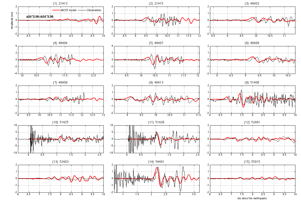
The Earth’s largest earthquakes and tsunamis are usually caused by thrust-faulting earthquakes on the shallow part of the subduction interface between two tectonic plates, where stored elastic energy due to convergence between the plates is rapidly released1,2. The tsunami that devastated the Samoan and northern Tongan islands on 29 September 2009 was preceded by a globally recorded magnitude-8 normal-faulting earthquake in the outer-rise region, where the Pacific plate bends before entering the subduction zone. Preliminary interpretation suggested that this earthquake was the source of the tsunami3. Here we show that the outer-rise earthquake was accompanied by a nearly simultaneous rupture of the shallow subduction interface, equivalent to a magnitude-8 earthquake, that also contributed significantly to the tsunami. The subduction interface event was probably a slow earthquake with a rise time of several minutes that triggered the outer-rise event several minutes later. However, we cannot rule out the possibility that the normal fault ruptured first and dynamically triggered the subduction interface event. Our evidence comes from displacements of Global Positioning System stations and modelling of tsunami waves recorded by ocean-bottom pressure sensors, with support from seismic data and tsunami field observations. Evidence of the subduction earthquake in global seismic data is largely hidden because of the earthquake’s slow rise time or because its ground motion is disguised by that of the normal-faulting event. Earthquake doublets where subduction interface events trigger large outer-rise earthquakes have been recorded previously4, but this is the first well-documented example where the two events occur so closely in time and the triggering event might be a slow earthquake. As well as providing information on strain release mechanisms at subduction zones, earthquakes such as this provide a possible mechanism for the occasional large tsunamis generated at the Tonga subduction zone5, where slip between the plates is predominantly aseismic6.
This is a preview of subscription content, access via your institution
Access options
Subscribe to this journal
Receive 51 print issues and online access
$199.00 per year
only $3.90 per issue
Buy this article
- Purchase on Springer Link
- Instant access to full article PDF
Prices may be subject to local taxes which are calculated during checkout


References
Kanamori, H. Rupture process of subduction-zone earthquakes. Annu. Rev. Earth Planet. Sci. 14, 293–322 (1986)
US Geological Survey. Largest Earthquakes in the World Since 1900. 〈http://earthquake.usgs.gov/earthquakes/world/10_largest_world.php〉 (2010)
US Geological Survey. Poster of the Samoa Islands Region Earthquake of 29 September 2009 - Magnitude 8.0. 〈http://earthquake.usgs.gov/earthquakes/eqarchives/poster/2009/20090929.php〉 (2009)
Ammon, C. J., Kanamori, H. & Lay, T. A great earthquake doublet and seismic stress transfer in the central Kuril islands. Nature 451, 561–565 (2008)
Okal, E. A., Borrero, J. & Synolakis, C. E. The earthquake and tsunami of 1865 November 17: evidence for far-field tsunami hazard from Tonga. Geophys. J. Int. 157, 164–174 (2004)
Bevis, M. et al. Geodetic observations of very rapid convergence and back-arc extension at the Tonga arc. Nature 374, 249–251 (1995)
Thatcher, W. Order and diversity in the modes of circum-pacific earthquake recurrence. J. Geophys. Res. 95, 2609–2623 (1990)
Pacheco, J. F. & Sykes, L. R. Seismic moment catalog of large shallow earthquakes, 1900–1989. Bull. Seismol. Soc. Am. 82, 1306–1349 (1992)
US Geological Survey. USGS Centroid Moment Tensor Solution. 〈http://neic.usgs.gov/neis/eq_depot/2009/eq_090929_mdbi/neic_mdbi_cmt.html〉 (2009)
US Geological Survey. Global CMT Project Moment Tensor Solution: Samoa Islands Region. 〈http://neic.usgs.gov/neis/eq_depot/2009/eq_090929_mdbi/neic_mdbi_hrv.html〉 (2009)
National Oceanographic and Atmospheric Administration. DART Buoy Comparison with Modelled Results. 〈http://nctr.pmel.noaa.gov/samoa20090929/dart-comparison-1.png〉 (2010)
Kanamori, H. Mechanism of tsunami earthquakes. Phys. Earth Planet. Inter. 6, 346–359 (1972)
Satake, K. & Tanioka, Y. Sources of tsunami and tsunamigenic earthquakes in subduction zones. Pure Appl. Geophys. 154, 467–483 (1999)
Bonnardot, M.-A., Régnier, M., Ruellan, E., Christova, C. & Tric, E. Seismicity and state of stress within the overriding plate of the Tonga-Kermadec subduction zone. Tectonics 26 10.1029/2006TC002044 (2007)
Aki, K. & Richards, P. G. Quantitative Seismology: Theory and Methods Vol. II 799–849 (Freeman, 1980)
Cifuentes, I. L. & Silver, P. G. Low-frequency source characteristics of the great 1960 Chilean earthquake. J. Geophys. Res. 94, 643–663 (1989)
Dominey-Howes, D. & Thaman, R. UNESCO-IOC International Tsunami Survey Team Samoa, Interim Report of Field Survey 14th-21st October 2009. Misc. Report No. 2, 26–27 (Aust. Tsunami Res. Centre, Univ. New South Wales, 2009)
Wilson, K. J. et al. Post-Tsunami Survey of Niuatoputapu Island, Tonga, Following the 30th September 2009 South Pacific Tsunami (GNS Science Report 2009/71, Institute of Geological and Nuclear Sciences, 2009)
Freed, A. M. Earthquake triggering by static, dynamic and postseismic stress transfer. Annu. Rev. Earth Planet. Sci. 33, 335–367 (2005)
Linde, A. T. & Sacks, I. S. Slow earthquakes and great earthquakes along the Nankai trough. Earth Planet. Sci. Lett. 203, 265–275 (2002)
Frohlich, C. et al. Huge erratic boulders in Tonga deposited by a prehistoric tsunami. Geology 37, 131–134 (2009)
Sobolev, S. V. et al. Tsunami early-warning using GPS-shield arrays. J. Geophys. Res. 112 10.1029/2006JB004640 (2007)
Song, Y. T. Detecting tsunami genesis and scales directly from coastal GPS stations. Geophys. Res. Lett. 34 10.1029/2007GL031681 (2007)
Blewitt, G. et al. GPS for real-time earthquake source determination and tsunami warning systems. J. Geod. 83, 335–343 (2009)
US Geological Survey. Finite Fault Model. 〈http://earthquake.usgs.gov/earthquakes/eqinthenews/2009/us2009mdbi/finite_fault.php〉 (2009)
Dach, R., Hugentobler, U., Fridez, P. & Meindl, M. Bernese GPS Software Version 5.0 (Astronomical Institute, Univ. Bern, 2007)
Okada, M. Surface deformation due to shear and tensile faults in a half-space. Bull. Seismol. Soc. Am. 75, 1135–1154 (1985)
Wang, X. & Liu, P. L.-F. An analysis of 2004 Sumatra earthquake fault plane mechanism and Indian Ocean tsunami. J. Hydraul. Res. 44, 147–154 (2006)
Coutant, O. Expression of the Green’s Functions in Cylindrical Coordinates used with a Reflectivity Method. Tech. Report (Laboratoire de Géophysique Interne et Tectonophysique, 1994)
Acknowledgements
We thank the following agencies for their publicly available data: New Zealand GeoNet, Geoscience Australia, the US National Geodetic Survey and the International GNSS Service (for GPS data); the NOAA (for DART data); and the USGS and the IRIS Data Management Center (for seismic data). We thank the governments of Tonga, Samoa and Niue, and the Niue Meteorological Service, for supporting GPS data collection in their countries in partnership with GNS and Ohio State University; ‘A. Pongi, M. Archbold, D. Matheson and R. Williams for their contributions to GPS observations at Niuatoputapu; D. Caccamise and R. Smalley for their efforts with the Samoan high-rate GPS data; M. Chadwick, J. Haines and D. Agnew for discussions; and L. Wallace for a review. The Coulomb stress modelling used software GNSTRESS2 by R. Robinson.
Author information
Authors and Affiliations
Contributions
J.B. processed and modelled the GPS data. X.W. modelled the DART and tsunami run-up data with support from G.P. and W.P. C.H. modelled the seismic data. K.W. and W.P. made field observations of the tsunami effects in Samoa and on Niuatoputapu. R.K.’s team at the Tonga MLSNRE has been instrumental in the collection of GPS data from Niuatoputapu, including the critical post-earthquake observations, and they also made field observations of tsunami effects. M.B. analysed high-rate GPS data. J.B., X.W., C.H., M.B., K.W., G.P. and W.P. were responsible for the data interpretation and all authors discussed the results and commented on the manuscript.
Corresponding authors
Ethics declarations
Competing interests
The authors declare no competing financial interests.
Supplementary information
Supplementary Information
This file contains Supplementary Texts 1 -7, Supplementary Tables 1-6 and Supplementary Figures 1-11. (PDF 6394 kb)
Rights and permissions
About this article
Cite this article
Beavan, J., Wang, X., Holden, C. et al. Near-simultaneous great earthquakes at Tongan megathrust and outer rise in September 2009. Nature 466, 959–963 (2010). https://doi.org/10.1038/nature09292
Received:
Accepted:
Issue Date:
DOI: https://doi.org/10.1038/nature09292
This article is cited by
-
Slow deformation event between large intraslab earthquakes at the Tonga Trench
Scientific Reports (2021)
-
Backwash sediment record of the 2009 South Pacific Tsunami and 1960 Great Chilean Earthquake Tsunami
Scientific Reports (2020)
-
Seiche Effects in Lake Tekapo, New Zealand, in an Mw8.2 Alpine Fault Earthquake
Pure and Applied Geophysics (2020)
-
The Tsunami Inundation Hazard of the Maltese Islands (Central Mediterranean Sea): A Submarine Landslide and Earthquake Tsunami Scenario Study
Pure and Applied Geophysics (2020)
-
Modeling of normal faulting in the subducting plates of the Tonga, Japan, Izu-Bonin and Mariana Trenches: implications for near-trench plate weakening
Acta Oceanologica Sinica (2018)
Comments
By submitting a comment you agree to abide by our Terms and Community Guidelines. If you find something abusive or that does not comply with our terms or guidelines please flag it as inappropriate.
